Parliament advocates right skills, mindset for surveyors at K’dua confab
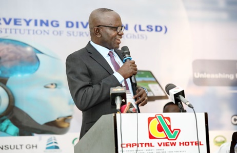
The Chairman of the Parliamentary Select Committee in charge of Lands and Forestry, Francis Manu-Adabor, has called for the equipping of the next generation of land surveyors with the right skills and mindset.
He indicated that while such skills and mindset had become necessary, the use of modern techniques in surveying would ensure that Ghana remained at the forefront of the surveying technological revolution.
The new method comprises the use of Geospatial Artificial Intelligence (AI) and drones for aerial survey which makes surveying accurate and efficient, in contrast to the past when surveyors used traditional methods with a lot of challenges such as inaccuracy in mapping and demarcation of boundaries.
The Member of Parliament (MP) for the Ahafo Ano South East Constituency in the Ashanti Region made the call when he addressed the 2024 annual conference of the Land Surveying Division of the Ghana Institute of Surveyors (LSD-GhIS) at Koforidua, the Eastern Regional capital, last Thursday.
The three-day event, with the theme: "Revolutionising Land Surveying: Unleashing the Power of Geospatial Artificial Intelligence (AI) and other modern techniques” was attended by surveyors of the Land Division drawn from all parts of the country.
Addressing challenges
The meeting took stock of the previous year's activities and planned ahead with the view of addressing inherent challenges.
![]()
Participants in Koforidua
It also schooled participants in the advantages and disadvantages of using AI in the land surveying profession.
Mr Manu-Adabor said as Ghana embraced the innovations in surveying, the country would have many opportunities and at the same time face challenges, such as upskilling and reskilling to harness new technologies, ethical considerations and data management strategies, as well as to ensure accuracy, reliability and integrity.
The President of the GhIS, Dr Anthony Arko-Adjei, said as land surveyors, they should remain steadfast in their commitment to excellence, integrity and public trust and that the surveying institution was committed to fostering a culture of innovation, collaboration and knowledge sharing.
Dr Arko-Adjei said AI and other modern techniques reflected the leadership of the Land Surveying Division's commitment to embracing innovation and pushing the boundaries of the land surveying profession.
He said it was clear that emerging technologies had been redefining the entire surveying profession and landscape, adding that the era of a fast-paced world driven by technological advancement made it necessary for the conference to deliberate on AI in land surveying.
The Omanhene of the New Juaben Traditional Area, Daasebre Kwaku Boateng III, said as custodians of land they had recognised the vital role Lands Surveying Division had been playing to ensure accurate demarcation, mapping and sustainable mapping of lands.
He said there was, therefore, the need for effective collaboration between the Land Surveying Division and indigenous governance structures, to safeguard and promote responsible land management practices and mitigate potential land disputes.
Daasebre Boateng indicated that the chief's partnerships with the Land Surveying Division had presented a unique opportunity to enhance land acquisition processes, verification of boundaries between neighbouring towns as well as implementation of land-use planning strategies.
Writer's email: haruna.wunpini@graphic.com.gh

